Hiking Acadia: Jordan Cliffs to South Bubble

Part I of the Hiking Acadia series.
Click here for Part II: The Most Dangerous Hike in Acadia: Precipice Trail
And here for Part III: The Beehive

On this Hike:
A dramatic climb along the cliffs of Penobscot Mountain.
The best views of Jordan Pond, from all angles.
Iron rungs and exposed scrambles.
A glacial erratic boulder barely balanced on a cliff edge.
And 360 degree views of the Jordan Pond area from the top of South Bubble.
Part I: Jordan Pond House and the Carriage Road
I got to the Jordan Pond area in the late afternoon, and it was packed. I had to circle the parking lot several times until I found someone leaving.
I didn’t mind, as most visitors seemed to only be there for a quick walk around to enjoy the views while grabbing lunch at Jordan Pond House. A little overpriced and overrated place in my opinion.
Of course I didn’t develop that opinion until I had already eaten my $20 three-inch lobster roll.
After my pre-hike lobster lunch, I made my way down to the lakeshore and headed west onto the Carriage road.

The views were already breath taking and I hadn’t even started.
The flat and even terrain had the slightest of inclines, and made for a decent warm up stretch.
Part II: Cliff Side Climbing
As the road twisted and curved up the hill, there was an easy to miss sign marking the turn-off for the Jordan Cliffs Trail.
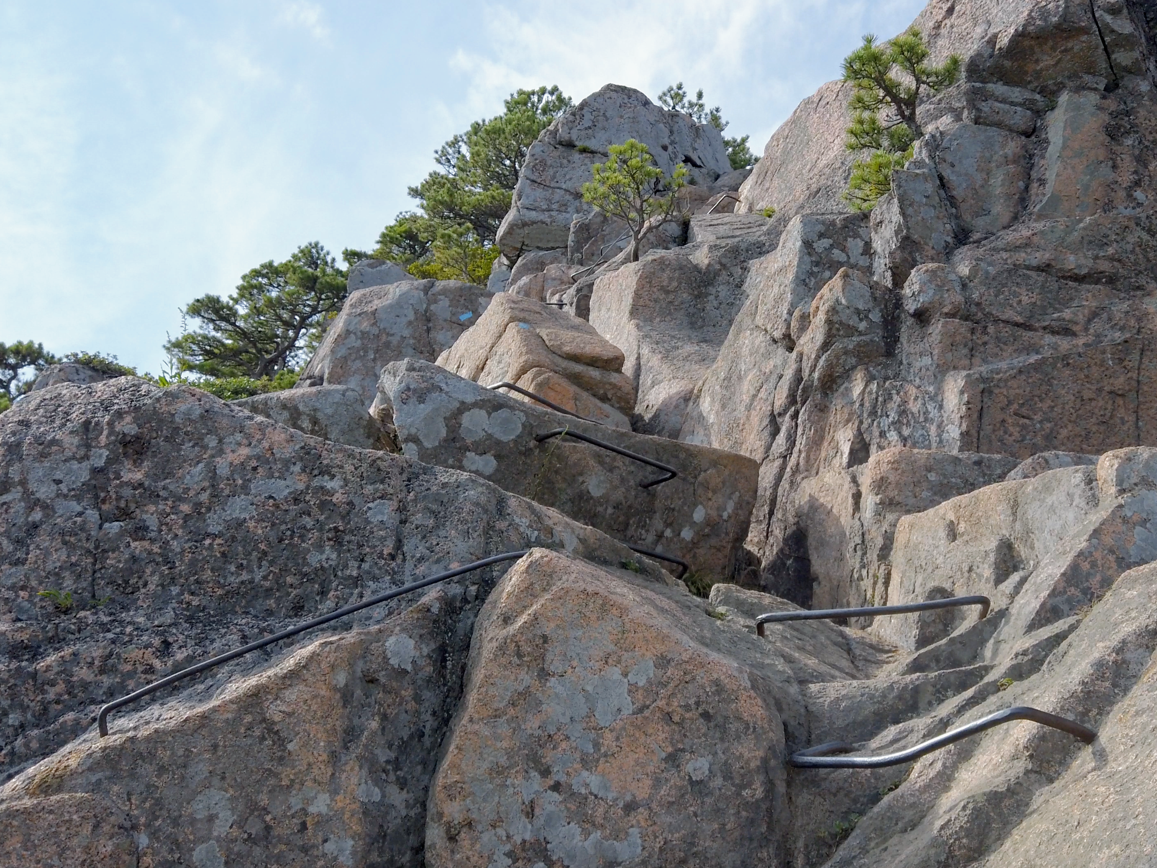
Just beyond that was another sign, warning about exposed cliffs and fixed iron rung climbs.
Sounds like fun.
I would definitely not call this a beginner hike. Especially for those with a fear of heights. But for those looking to build up the courage to take on other climbs like Beehive Mountain and Precipice Trail (links coming soon), this is a great starter adventure to get yourself used to those fun iron rung scrambles.
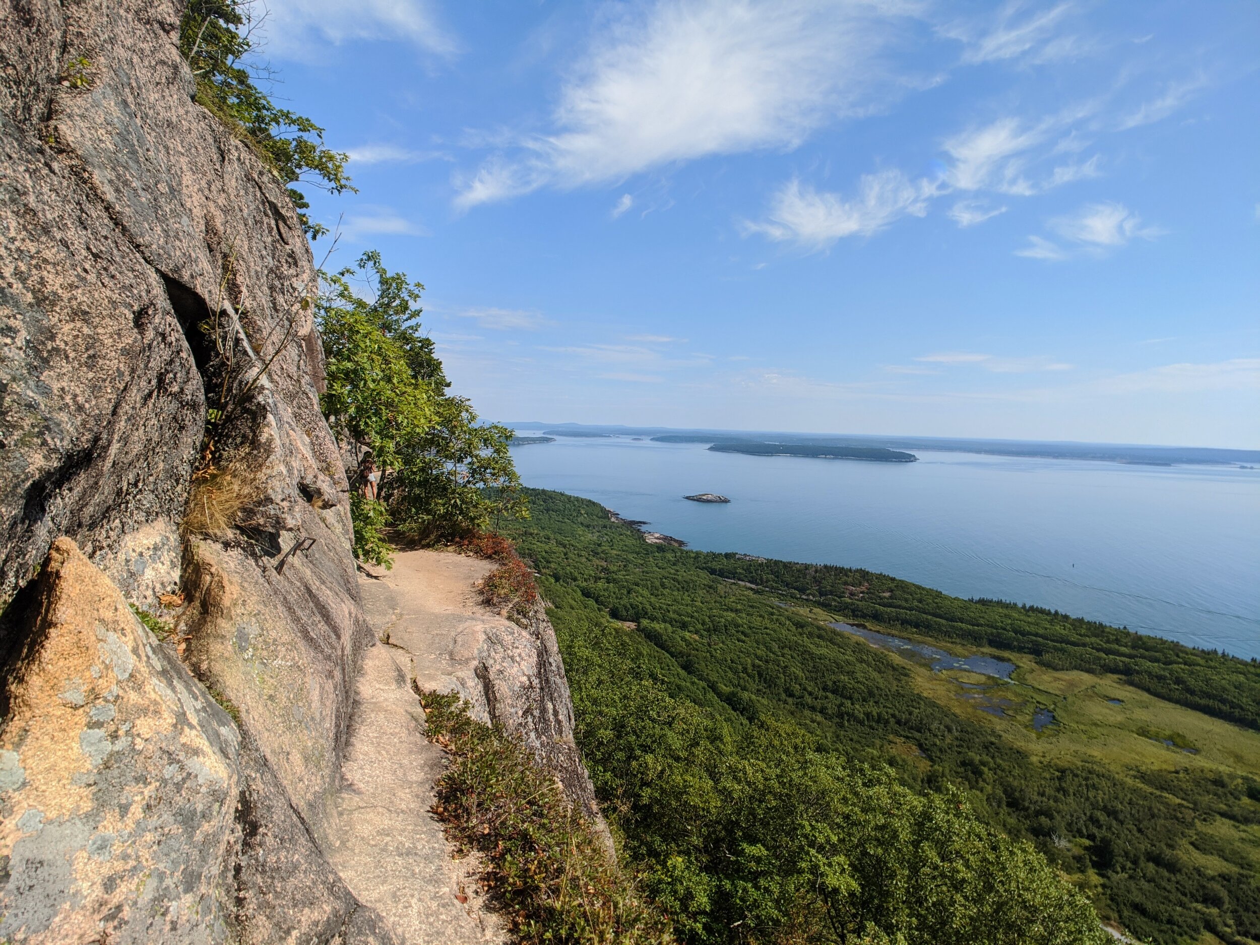
From here the trail climbed in elevation, but began to level off as the cliffs became more apparent and I got my first glimpse of amazing vistas this trail had to offer.


The scene was dominated by Jordan Pond below, with Pemetic Mountain directly across, and The Bubbles, just north of that.
As I continued on, the real fun began with some stone steps leading to the first perch.
The steps soon turned into ledges with rocky hand holds, which then turned into slabs with iron rungs.

This continued on for a bit, but there seemed to be a ledge after each scramble to allow me to catch my breath and enjoy the view.
Between two scrambly sections, I came across a long and narrow one-log bridge. There were steps cut into it, but I felt like a gymnast on a balance beam going down it.

If balance beams had handrails, that is.
Part III: Down to the LAKESHORE, and Up to the Bubbles!
At exactly two miles, I turned East onto the Deer Brook Trail and descended rapidly down Penobscot Mountain.
After crossing a road to descend further into the valley, I came across the double arched Deer Brook Bridge.
The contrast of the architectural masonry hiding amongst the wild landscape was visually poetic.

1925, the year of construction is set into the bridge’s circular medallion.
Finally at the base of the valley, I emerged out of the woods and onto Jordan Pond's rocky shores.
From here I could see the shadow of Penobscot Mountain climbing its way up the mountains to my left. I was going to have to hussle if I wanted to make it back to the parking lot in daylight.
Or more importantly, make it to the top of South Bubble in time for golden hour.
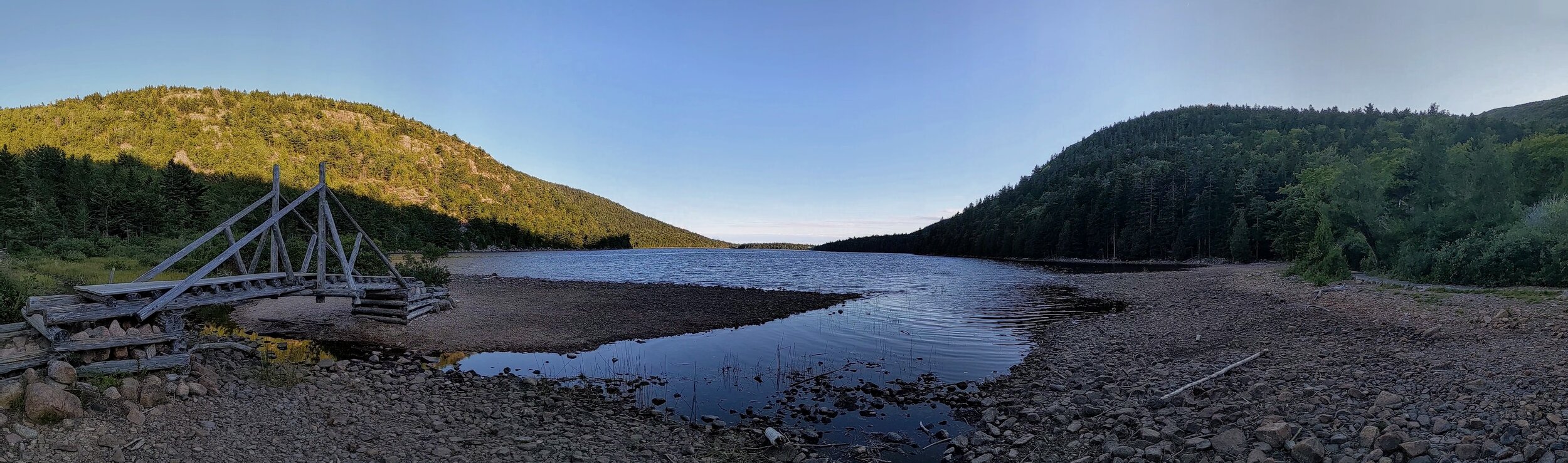
So off I went. Hastily crossing an over-engineered bridge over a disproportionately tiny creek, and chased that shadow up the hill.
The climb up the Bubble Divides trail was short but strenuous. At times reaching a 50% steepness grade. And all of it jumping between rocks that were just shy of being called boulders.
Boulderettes?
There was a reprieve from the steepness in the cleavage between the geological boobs that were North and South Bubble.
Don’t lie. You thought it too from that first picture.
If I had more time, I would have liked to have done a quick out-and-back run up to North Bubble too, but the shadow of Penobscot was hot on my trail.
Part IV: Glacial Granite and the South Bubble Summit
I approached the summit as the dappled evening light was shining through the trees.
And that's when I saw it. The most iconic part of this entire hike, Bubble Rock, leaning over the eastern edge of the South Bubble Summit.

Pushed here by a bored glacier playing 'kick the can' 2.6 million years ago, this precariously perched black and white boulder stands out among the native pink granite of Acadia.
It is in fact made up of bedrock from 40 miles away, and was one of the first clues that led 19th century scientist Louis Agassiz to theorize that massive glaciers once covered the earth and pushed big boulders around.
I took a few moments to appreciate this gem of geological history, and took the touristy (but absolutely necessary) photo of me attempting to “push” the boulder over the edge.
(Oops. Must have lost those shots)
From there, as the sun retreated behind the mountains, and the area finally succumbed to shadow, I approached what was the best view of the hike.

Visualizing the entire trek, I point to where the day’s adventure began.
Part V: Ending the Jordan Pond Journey
Just when I thought the challenging parts were over, the descent down South Bubble had one more trick up its sleeve. A brief down-climb on the southern face that was just challenging enough to keep things interesting.
Once I was back lake side, the last mile and a half of the hike was a flat and relaxing stroll around the Jordan Pond Path.
I stopped frequently to watch the sky turn colors, and listen to the silence of this mountain lake past sunset.
I must have been pretty silent myself, as I was snuck up upon by a beaver gathering wood for his hut.

As I rounded the final bend back towards the parking lot, I stopped to look back over the lake as the last bits of light fought to hold onto the day.
I decided to stay until it could hold on no longer, and hiked the last half mile by the light of my headlamp.

Hiking Guide:

Distance: 4.5 Miles
Elevation Gain: 1,145 ft
0 Miles: Park at one of the three parking lots near Jordan Pond House and head down to the lake shore. (Learn from my mistake and get there early, as the the lot fills up quick.)
0.2 Miles: Turn left onto Jordan Pond Path, and left again onto the ‘Around Mountain Carriage Road’
0.3 Miles: The carriage road splits. Take a hard left uphill to the East.
0.6 Miles: Keep an eye out for a small post on your right for Jordan Cliffs Trail. Turn north and enjoy the cliff side scrambles for the next 1.3 miles.
1.9 Miles: Turn Right and descend down Deer Brook Trail which will take you down the north end of Jordan Pond.
2.3 Miles: Ascend the Bubbles Divide Trail.
2.5 Miles: In the Bubbles Divide Saddle, turn right on the Bubbles Trail toward South Bubble
2.8 Miles: Bam! Your at the summit. Look left for a quick side trail to Bubble Rock on the east side of the summit. Then backtrack to the summit, and continue south for your last scramble of the day.
3.0 Miles: Turn left onto Jordan Pond Path, and enjoy the stroll all the way back to the parking lot for the next mile and a half.