Exploring the High Peaks Wilderness: Algonquin Peak and Mt. Marcy
Distance: 22 Miles
Elevation Gain: 6,047 ft
Peak Elevation: 5,345 ft
alltrails.com
There are 46 peaks above 4,000 feet in the Adirondacks*. But only two above 5,000: Algonquin Peak and Mt. Marcy. This summer I set out to backpack through the High Peaks Wilderness in an attempt to tackle these two 5,000 footers over the course of 3 days.
After plotting my route, I patiently kept an eye on the forecast, waiting for a window of good weather. Weather can be tricky in the High Peaks with its four distinct climate zones. Determined primarily by elevation, the Northern Hardwood, Boreal, Krummholz, and Arctic-Alpine zones’ weather patterns can change drastically from one to the next as you climb. So when a four day window of blue skies emerged, I packed my gear and headed North.

Day 1: The Journey Through Avalanche Pass
I started from the popular camp site, “Adirondak Loj”, just South of Lake Placid. After paying for parking I had my food storage gear checked by the local rangers. Bear canisters are required in this area, and only specific types are authorized. If you show up without one or the wrong type, you will be required to rent one.
I made my way past the scenic Heart Lake and onto the Old Marcy Dam Trail. There are many trails and herd paths that originate from this area, so I had plenty of options to choose from. Day 1 was going to be an easy day without a peak to summit, so I decided to get in some warm-up elevation gain and took the Whales Tail Ski Trail.
This was a mistake.
Pushing my way through the overgrown trail, about a quarter of the way in I saw a sign high up in the trees, “Trail For Skiing Only”. Crap. In the winter, I could see how this might be a fun ski route through the woods. In the summer though I was stepping in swampy marshland with mud up to my ankles. I’m assuming there had to be a sign closer to the start of the trail that was obscured by overgrowth. Too late to worry about that now though.
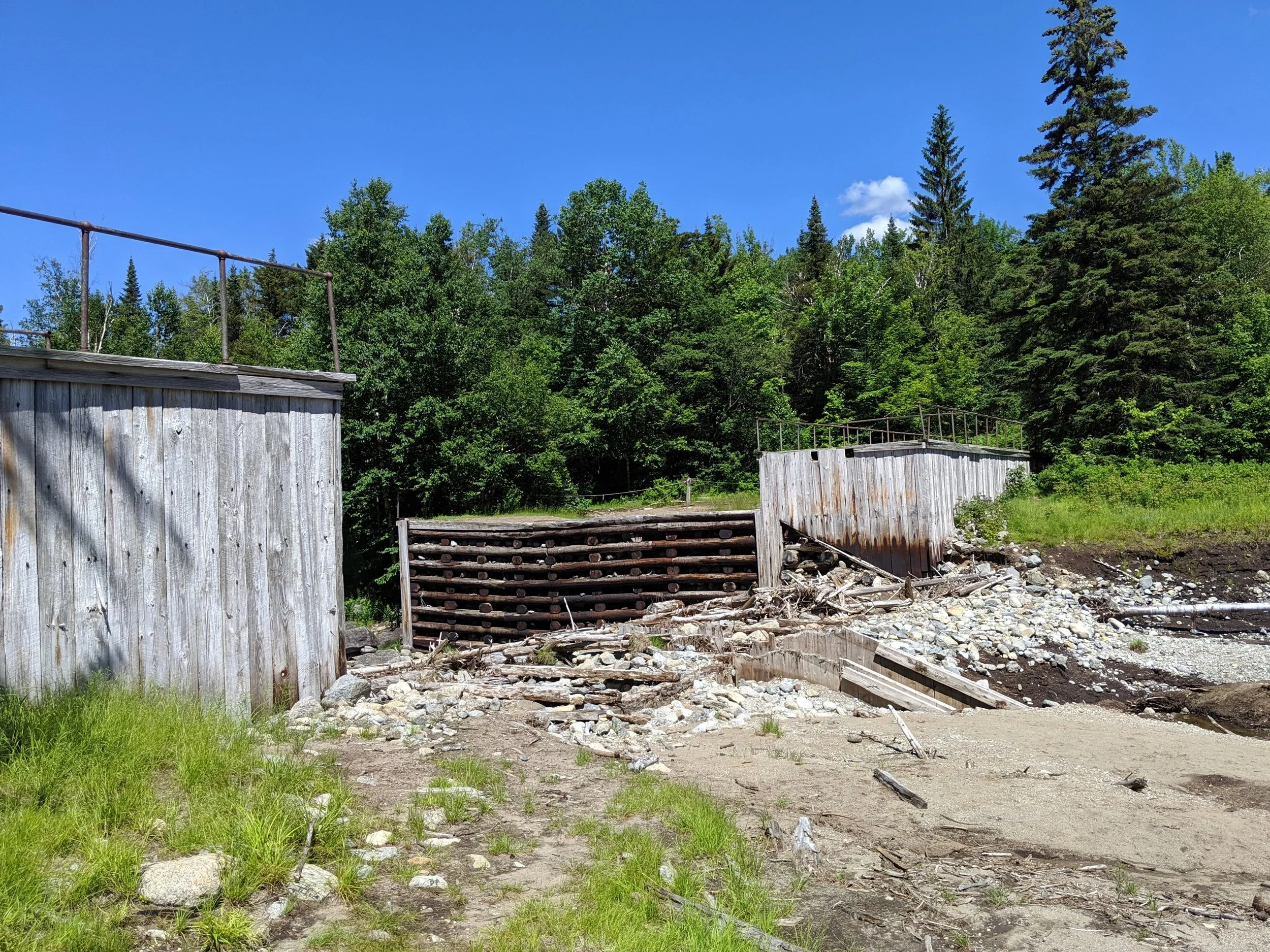
Eventually I made my way out of the mud and down to what used to be Marcy Dam. Long before this was a designated wilderness area, the logging industry built a series of dams here in the 1800s to help move logs. Unfortunately Marcy Dam was destroyed by Hurricane Irene in 2011, turning Marcy Lake into Marcy Stream. But the only thing constant is change.
Once past the stream I turned South heading towards Avalanche Pass for a couple more miles.
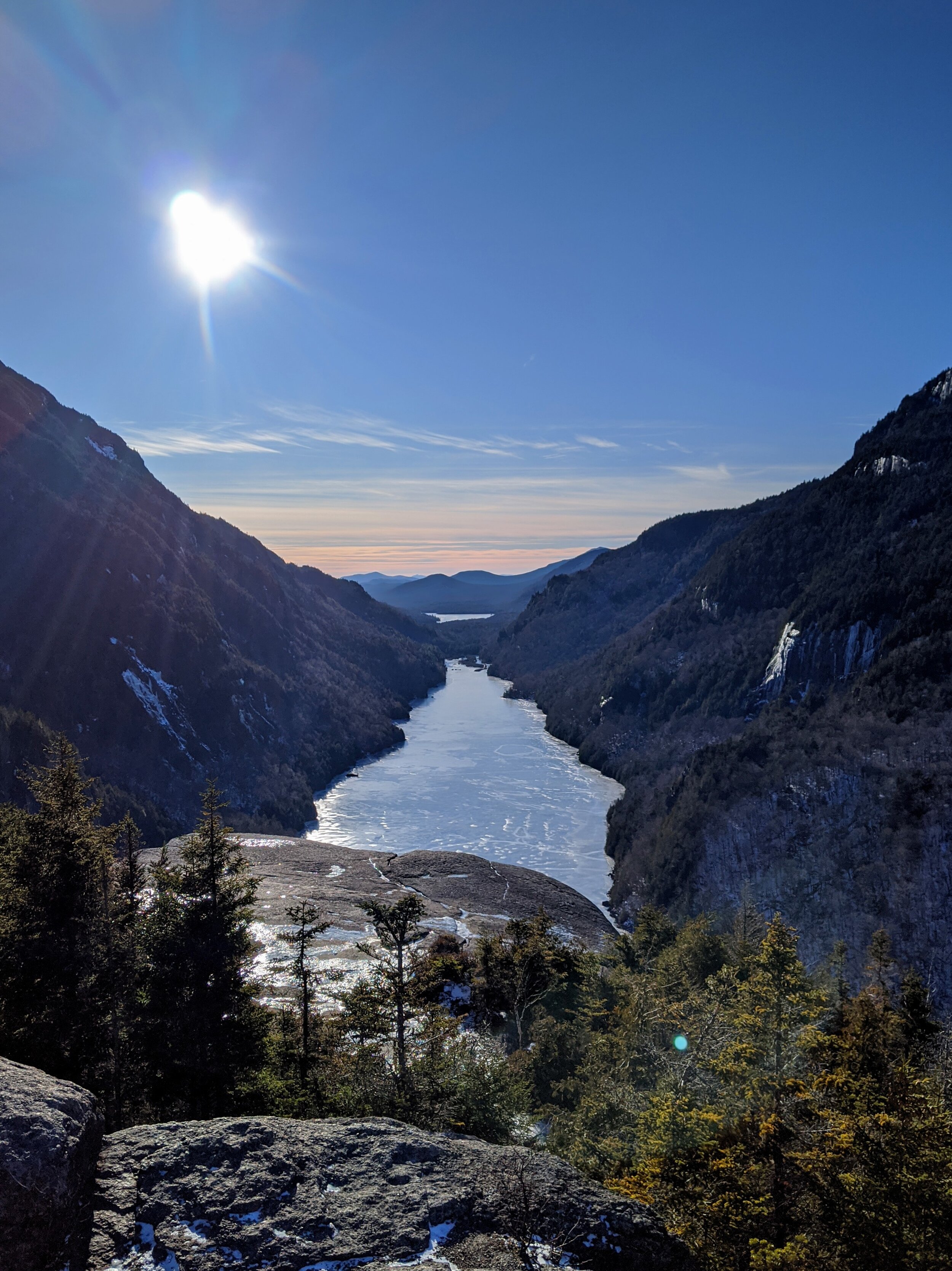
The pass was flanked by two steep walls of rock between Mount Colden and Avalanche Mountain. Not quite a canyon as much as just two very close mountains. The climate was noticeably different down here with humidity trapped between the ravine walls. It felt like a secret hidden rain forest.

Continuing on, the view opened up to the dominating landscape of Avalanche Lake. Here the hike turned into a scrambly climb over piles of large glacial erratic boulders from Avalanches past. There was the occasional assist from man-made ladders across particularly difficult traverses.

I am personally torn about these man-made aides. While I appreciate the assist, I couldn’t help but feel it took part of the “wilderness” aspect out of the wilderness. I could understand the need for them through more trafficked areas like national parks, but out here?

Okay, maybe this one was necessary
Once past Avalanche Lake, I took a moment to appreciate the view. After filtering some water I set up camp nearby in this cozy ravine. I took out my maps and plotted tomorrow's ascent up to Algonquin Peak.

Day 2: The Climb to Algonquin Peak
The morning was quiet and peaceful in the valley of these two mountains. While being serenaded by the forest birds, I took my time with breakfast and rechecked the maps. The goal of the day was the summit of Algonquin Peak. The second highest in the Adirondacks, and the only other 5,000 footer. After my last sip of coffee, I packed up and headed on my way.

Sometimes as you walk along a path in the woods you are just struck with certain scenery. The dappled morning sunlight trickling through the leaves into a mossy forest was one of those sights that really make you appreciate the opportunity to be out here.
Screw stopping to smell the roses. Stop to smell the pine needles.

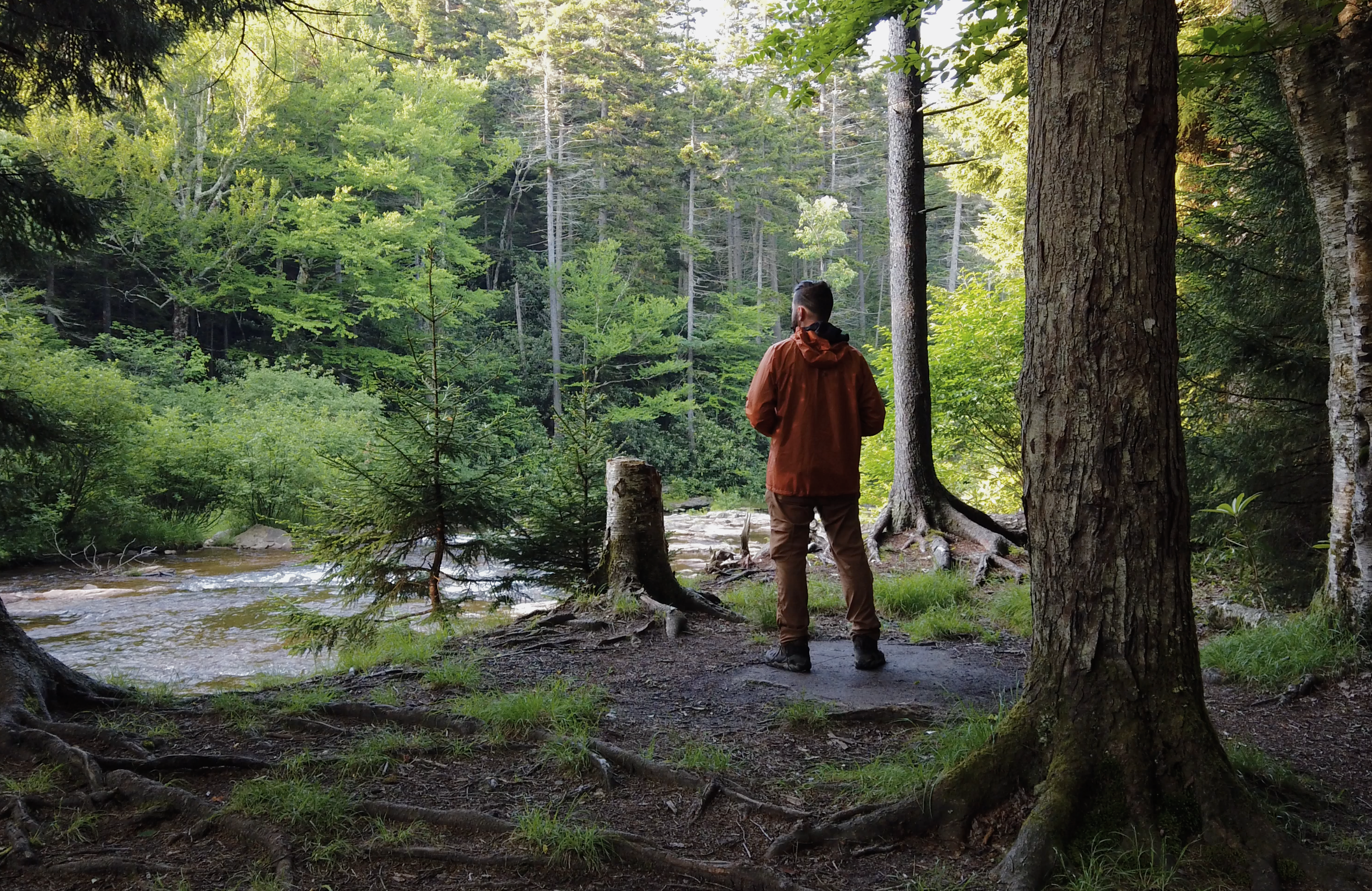
You will occasionally come across other hikers in the wilderness. And in this case, creepily take their photo from a distance because you think it’s a well framed shot. Here we have a backpacker in the wild signing an internal registry by one of the trail crossroads. It's always a good idea to sign in and out whenever possible, so park services can have a record of who's gone missing, and where they were last.
The fellow backpacker and I briefly chatted about where we were headed for the day. Wished each other luck and parted ways.
The trek up to Algonquin Peak was a six hour out-and-back side journey, so there was no reason to bring all my gear with me. I dropped my pack and took out my lightweight summit bag and filled it with the bare essentials.
I realized there would probably be hikers passing through at some point, so I found some loose birch bark and scribbled a note. I had no reservations about my gear being stolen, but wanted to let others know it wasn’t abandoned or that someone had gone missing.

I have always found backpackers to be among the friendliest, most trustworthy people. Maybe it’s the comradery of being in the wilderness, out here, alone together. Maybe it just takes a certain type of person to have fun venturing out into the wild. I have found that the further into the wilderness you go, the friendlier people get. After several days of backpacking, as you get closer to the trailheads and come across more day-hikers, people seem less apt to say hi.
Then again, maybe the fact that they’re passing a guy who hasn’t showered in a few days has something to do with it.
The first half of South-Eastern approach follows a series of waterfalls. Some I could easily hike the sides of, others I had to practice my scrambling skills to get around, all of them amazingly beautiful.

The higher I climbed the more I noticed a subtle difference in temperature and plants and trees around me. In this area, every 1,000 feet of elevation is the equivalent of driving 500 miles north, climate-wise. Which is why the peak is considered an Alpine-Arctic zone. It has a similar climate to that of the tundra of Northern Canada.
Above 3,000 feet and seemingly isolated only to the Boreal climate zone, there were tons of these little white flowers all over the place. If anyone could help me identify them, it would be appreciated.

Around this same elevation I saw a warning sign that I could barely make out.
"WARNING: Something something something do not proceed without proper gear"
whatever, probably not important.

The higher I got, the steeper the trail seemed to get. At some points approaching over a 45% grade. Exposed roots could be used as hand holds at some points, but there were areas that turned into more of a free-solo slab climb. That’s right, Alex Honnold aint got shit on me.
To get past I had to put my trekking poles on the lowest setting and stab them into the cracks and use them sort of like ice axes as I went up.
One particularly tricky slab area had just a wide crack down the middle. To climb up it without sliding down, I had to expand my fist into the crack and pull myself up. In rock climbing terms, this is known as a fist jam or fisting.
It is also known as that in other circles, and you usually have to pay extra.
As the trees got shorter and shorter, the trail became increasingly difficult to follow and was not clearly marked. Most hikers tackling this mountain take the Northern approach, not this side trail on the way to Marcy, so I suppose there is less incentive to maintain trail markers on this side. To make sure I was still on the right path I began to keep an eye out for scratches on rock left by the trekking poles and/or crampons of past climbers and that seemed to get me there.

At about 4,700 ft, the trees yielded and the bald cap of Algonquin began. Just another quarter mile or so to the top!
When you’re passing trees and bushes on the way up it gives you a sense of your own speed. But up here, with a clear view for miles and miles in every direction, time seemed to slow down.

Finally at the top, I sat and ate what seemed like the best lunch I had ever had. Peanut Butter and apples never tasted so good.

I had heard the view from Algonquin was one of the best in the High Peaks, even better than Marcy, and now I could see why.

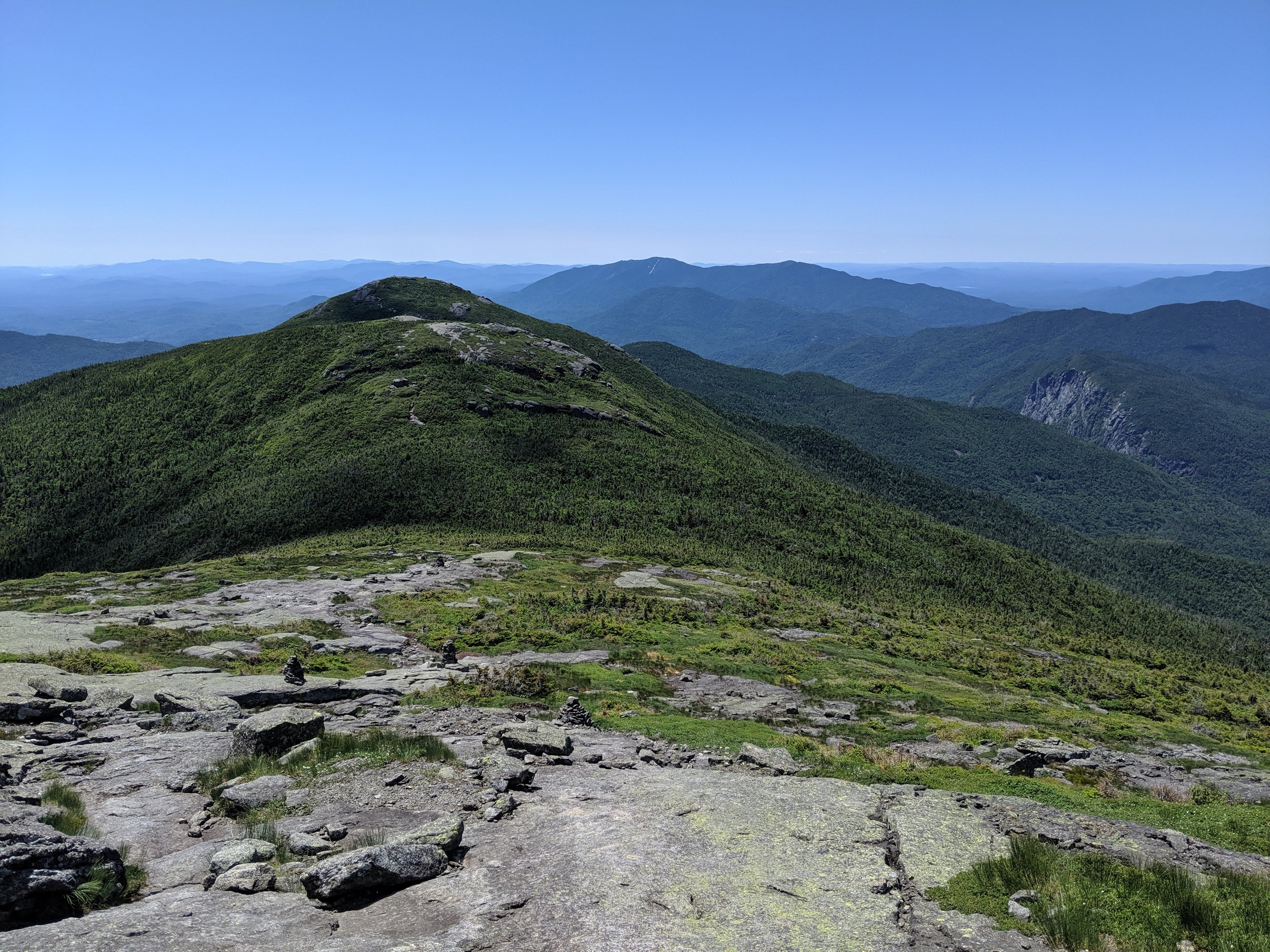
Of particular note was the scared face of Avalanche Mountain. When I first looked at this area on Google Maps, I thought there was a corruption of the photo data. It turns out these bright streaks are the scars of avalanches past, keeping the mountain true to its name.
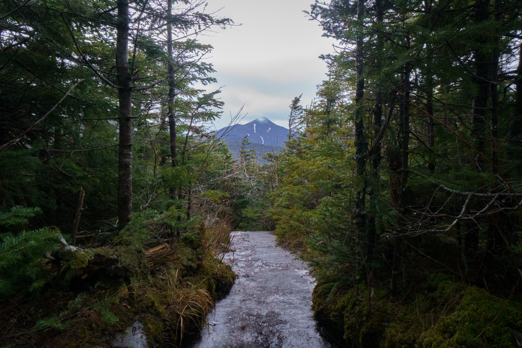
Beyond that, peaking above, was Mt. Marcy, the ultimate goal of this trip.
Tomorrow I'm coming for you, Marcy! …Shit, she's... She's right behind me, isn't she.
The way back down involved a lot of butt sliding and crab walking down those aforementioned slabs (thanks elementary school gym class!).
Eventually after reclaiming my pack at the base of Algonquin I found myself traveling around Lake Colden. After I passed a series of lean-tos and primitive shelters on the South-East end of the lake I continued on to establish a camp on the babbling brook that is the Opalescent River.
After a long day of climbing, I couldn’t have dreamt up a better place for some rest and relaxation.

Dinner reservations at the Opalescent River

I think I’ll stay here till morning.
Day 3: The Ascent of Mt. Marcy
Just before dawn I was startled awake by a bear that had wandered into camp, rustling through the leaves.
...Okay maybe it was a mouse.
Bears and mice sound strikingly similar when they wake you out of a deep sleep.
I yelled and clapped until the rustling stopped. I guess I will never know what you were, Mr. Bear-Mouse. Hey, that’s a pretty good name for a band.
Once I gathered the energy to roll out of my tent, I went to check on the food in my bear canister.
Sweet. Still there.
I made myself some breakfast and an extra cup of coffee back by the river. Today was going to be a long day. The longest of the trip. I had packed enough food for four days in case some bad weather came through preventing me from getting to the summit. But if everything went well, I could push it and do it in three.
Half of today’s miles would be descending Mt. Marcy where I could probably pick up some speed. Plus I would be descending the North face of the mountain which had a more forgiving slope than the Southern approach I was currently on. With an early start, if all went well, I could be out of the High Peaks Wilderness and back to my Jeep by sundown.
So off I went, onward and upwards.
I was surprised at how muddy the trail was up here. I found myself log hopping through swamps and stepping on large exposed roots to not sink in. There is a big debate among backpackers between waterproof footwear verses breathability, but I feel like on this trail, at this time of year, waterproof boots were a must.

Again I noticed the trail was not very well marked out here. And when there were trail markers they sometimes changed colors despite being the same trail, and none of them were labeled with the name of the trail. I found myself consulting my map frequently.
At about 3,400 feet, the mud stopped and the rocks began.
I got to climb alongside some amazing cliff waterfalls with plenty of spots to rest and take in the scenery.
Any one of these spots I would have day-hiked out to for their view alone.


At the junction of Lake Arnold Trail, a nearby sign noted the elevation at 3,500 ft.
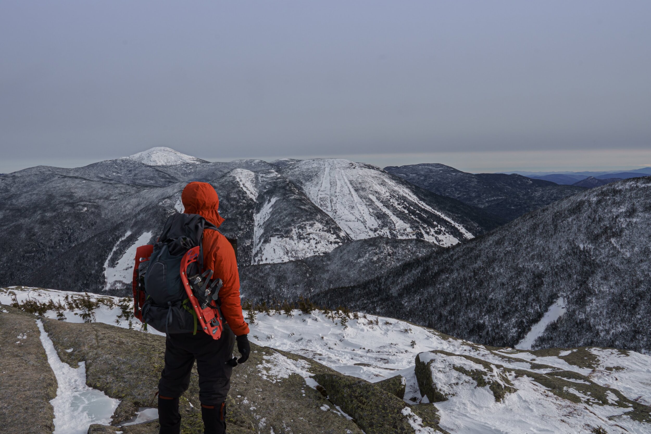
At one point there was a clearing in the trees. I looked up to my left and saw this dominating mass of a mountain and thought, “Oh wow. I’ve got to climb THAT thing!?” Just to then turn the corner to have the much larger Mt. Marcy dominant my view. “No... I’ve got to climb THAT thing. Yikes.”
Continuing on, there was another sign: “Elevation 4,000 ft. Camping is not permitted above this elevation.”
Soon after, I came upon Lake Tear in the Clouds and stopped to filter some water. This lake is famous for being the highest lake in New York State, and for being the highest source of water that eventually becomes the Hudson River, flowing all the way down to NYC. For me it was famous for it’s merciless mosquito population.


There was also some interesting rock art nearby. If anyone knows the story behind this, let me know.
Just past the lake came what's known to peak-baggers as the 4 corners, connecting trails to several of the high peaks in the area. From here it was a straight slabby and bouldery climb to the highest point in NY
The climb from here was breathtaking. As the trees got shorter and shorter, I couldn’t help but to turn around and get a peek of the view that was about to come.
Eventually the trees stopped and the real fun began. About a mile climb of steep open rock to the top of NY State.


Not going to lie, at this point after days of elevation gain, I was beyond exhausted. I could only climb a few feet at a time before I had to rest to catch my breath and seriously question why I do this to myself. But just up ahead there was a peak that needed to be summited. And I was just within reach.
Coming in at 5,344 feet, and over four Empire State Buildings high, Mt. Marcy is New York’s truest sky scraper. Finally at the top, I could now count my name among the countless others who have stood upon this peak. Starting with the first successful summit in 1837, when the mountain was renamed after NY Governor William Marcy who authorized that first expedition. Before that, the mountain was called by the Native American name Tahawus, meaning “Cloud Splitter”.
Exhausted and out of breath, the only thing left to do was to have lunch and enjoy the view while having a celebratory summit cigar.


And then it was all downhill from there.
I could have easily broken up the Marcy decent into two days. I had the supplies for it.
But the weather was good and gravity was on my side so I decided to push it.
After a few hours I came to the best view on this side of the mountain, Indian Falls. I took a break here to get a refill on water. Taking a stroll East down the falls trail, the woods opened up to a spectacular view of Algonquin, Wright, and Iroquois peaks, where I had stood two days earlier. It allowed me to reflect on how much ground I had covered in the last few days and the vastness of this beautiful wilderness area.

I perhaps stayed there a little too long as the shadows were getting longer and I still had some miles to go.
As I picked up the pace I got sloppy with my footing. While hoping between boulders, I rolled my ankle on a landing. This would be painful enough on its own, but add in a 30 pound pack toppling you end over end and it’s a day ruiner.
Luckily I already had enough ibuprofen running through me to numb a rhino.
Finally, as the sun was setting, I made it back to my Jeep and finally dropped my pack.
Thanks for the great trip Adirondacks. I will definitely be seeing you again.